Manaslu Tsum & Manaslu Trek

The Tsum Valley, also known as the Hidden Valley a land of monasteries and hamlets with totally Tibetan population lies on the northern part of Manaslu on the Nepal-Tibet border and used to be a restricted area until 2008. Although the region lies within Nepal, the Buddhism influenced region is a world of its own. Traditionally, Tsum used to be a separate area different from both Nepal and Tibet. The Tsum Valley region is still less exposed in comparison to other tourist areas, with relatively virgin and less beaten paths in comparison to the more popular regions. The Tsum people have their own way of family life, which may be quite surprising for many outsiders. All the brothers in the family are married to a single girl, what you may call a practice of polyandry. Compared with other areas, The Tsum Valley and Manaslu area is full of imminent mountains, passes, deep gorges, hamlets, gompas, chortens, and mani walls.
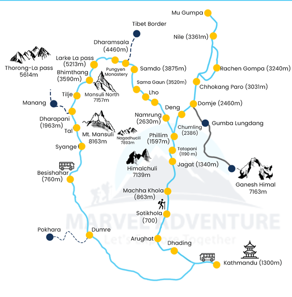
The trek to Tsum Valley takes you into the majestic surroundings of the Ganesh Himal, Sringi Himal, and Boudha Himal ranges. In the initial days of the trek, we explore the Budhi Gandaki Valley through a mix of dense forest, terraced fields and hill villages. As we leave the main Manaslu Trail for the Tsum valley, suddenly we get a feeling of entering truly into the hidden valley. While on the trek, we also pass through the alpine forests, glacial rivers, and enjoy the warm hospitality of ethnic people. We also visit the ancient Buddhist Gombas of the region including the Milarepa's Cave, Rachen gompa, Mu Gompa among others.
Itinerary
Day 01
Kathmandu to Arughat Bazar by bus/jeep (8-10hrs)
You can take a direct bus from Kathmandu to Arughat, a rough unsealed road from Dhading to Arughat. In Arughat (600m), a pleasant market town straddling the Budhi Gandaki river, walk into town, cross the suspension bridge.
Day 02
Arughat to Lapubesi (5-6hrs)
Many now take a jeep to Soti Khola to save 3hrs of walking but the road remains untrafficked and passes through pleasant fields and villages. Trek through Gurung and Magar villages on the more scenic upper road where there is a choice, staying on the left bank (true right) of the Budhi Gandaki, which you will be following to its source. It is around 1.30 hrs walk to town of Arkhet (760m) could easily be your first night if you arrive early enough from Kathmandu. Climb on stairs as the valley becomes wilder, prettier and narrower and descend to Soti Khola (710m). There’s a swimming hole in the Soti Khola, popular with locals. Packhorses ply the trail from here on. Trek on through shady sal forests then climb up and down for some time on an exposed track blasted from the cliff and views way below of wild rapids, eventually dropping to the Gurung Labubesi (880m; Lapubeshi).
Day 03
Lapubesi to Tatopani (4-5hrs)
Continue up-river, climbing sometimes and at other times down on the gravel riverbed, passing through Machhakhola (930m), continue on the same side of the Buri Gandaki, up and down again and across sandy riverflats. The monkeys and langurs in the jungle above can knock rocks down, so watch out. Large Gurung villages are way above while the track passes few houses, like lower Khorlabeshi (960m) which was largely destroyed by a huge rockslip 24 years ago. Goat herders passing through this area wear the distinctive smoke-browned capes called bokkhu made famous in the book Honey Hunters of Nepal. Continue up and down over a couple of ridges to Tatopani (930m; ‘hot water’) where there are hot water spouts under the sheer cliffs that provide a delightful evening shower and soft skin due to natural minerals.
Day 04
Tatopani to Philim (5-6hrs)
Climb over a ridge and cross the Buri Gandaki on a new suspension bridge, circle under cliffs and climb a little to Doban (1000m; Duvan). After a landslip and Yaruphant (1140m) cross the bridge across the Yaru Khola (1363m) and emerge onto riverflats at Yaru (1140m) for lunch. Look downstream at the massive rockfall that chokes the river. Just past Yaru, cross to the true right bank and enjoy easy up and down to Jagat (1410m), a neatly flagstoned Gurung village where jagat (‘tax’) is collected on Tibetan trade. Walk up the riverbed then climb over a rocky ridge to Salleri (1440m) with views of Sringi Himal (7187m), then descend to Sirdibas (1430m; Setibas, Tara). You’ll see your first signs of Buddhist culture here. Look out for rakshi spirit being distilled from millet beer in roadside kettles on this day. Continue up-river on the left bank, up and down before crossing Nepal’s longest suspension bridge to the east bank and a tiring climb up to prosperous Philim (1590m; Dodang) surrounded by rich fields of maize, potato and millet.
Day 05
Philim to Chumling (5-6hrs)
Traverse north out of Philim on the obvious track signposted to the Larkya La, through some pretty forest with views up the narrowing valley. After 1hr climbing enter the increasingly misnamed Ekle Bhatti (1600m; ‘lone teashop’) with at least six bhatti, then traverse high above a spectacular gorge, entering a largely uninhabited area of pine trees. Eventually drop to a trail junction going left to Ghap and right to the Tsum Valley, just above Gum Pul (‘bridge’). Climb on a well-graded but exposed track through pines and rhododendrons, looking down on the other trail across the river. Climb on zigzag steps, increasingly exposed, and gain your first glimpses of the narrow lower Tsum Valley, very steep across the Siyar Khola (Shiar Khola) which drains from the very top of the valley. Across the Buri Gandaki is Himalchuli (7893m) above steep cliffs. Walk through a largely intact and peaceful temperate forest into Lokpa (2240m; Lakuwa), surrounded by barley fields. Descend through beautiful forest, crossing two new bridges, circle under a huge bluff on the river then climb steeply on deteriorating exposed stairs. After about 30mins start to traverse north through pines and rhododendrons, still climbing and with very steep slopes. The hidden valley of Tsum stretches enticingly ahead. Eventually descend to a deserted bhatti Ghumlong (2130m) on the river. The path straight ahead climbs steeply to Ripchet (2470m; Ripche) in about 1hr; the path to Chumling (2360m) crosses the Siyar Khola on a wooden bridge and up. After about 30mins, below Chumling, take the level track to right (east) for 15mins to arrive at a lodge with 6-8 beds. Make sure you climb up to Chumling and check out the old gompa, the traditional houses, orchards, clinic and beautiful stone streets. This is Buddhist agriculture, with conical pine needle haystacks among the prayer flags. From here on trails are lined with artistic chortens and mani walls made of thousands of stone slabs carved with deities and prayers.
Day 06
Chumling to Chhokang-Paro (3-4hrs)
Cross the suspension bridge just east of the hotel and traverse through rich farming land of maize and potatoes. The houses are classic Tibetan with barricades of firewood on the roof, but without flat roofs as it rains and snows here. Cross a huge slip where rocks and flood cleared the area even up onto the opposite bank, covered with a forest of new trees. Up the valley to the east are superb views of several of the 7000-7400m Ganesh Himal, of long suspension bridges on the opposite bank, and far above the perched village of Ripchet (2468m). Cross the Serpu Khola and climb for over 2hrs on well-graded but exposed track to upper Tsum and the joined villages of Chhokang-Paro (3010m), stone houses with a few iron roofs nestled under cliffs. The valley opens here into spacious fields of barley, maize, buckwheat and potato, but wheat has been abandoned due to ‘hill bunt’, a disease which turns the heads black and causes total crop failure. Herds of thar often graze the wild cliffs to the north, coming right down to the fields. If the air is clear Himalchuli (7893m) can be seen down valley.
Day 07
Chhokang-Paro to Nile (3-4hrs)
Most people can climb to 3000m without getting altitude sickness, but the altitude gain in these track notes above Chhokang-Paro is right at the 300m per day suggested for safety. Explore the village. Thar are often sighted near here. The friendly people speak Tsumba, related to Tibetan, but often little Nepali and are quite unused to visitors.Head east through small villages and past a local school, climb over a ridge of chortens and past Lamagaon (3202m) through the flat fields, looking across the extensive crops and river to the huge courtyard of the Rachen Gompa (3240m). This nunnery is the female equivalent of the main Kathmandu Kopan Monastery. Pay visit to Milarepa’s Cave (Piren Phu), where the bringer of Buddhism to Tibet is reputed to have meditated. The nunnery is noted for the murals in the temples, and though the track to it is rougher than some, the climb provides great views of Ganesh Himal. Continue up over a high ridge to the village of Nile (3360m), where you can enjoy fabulous mountain views of the border with Tibet and the big peaks looming above, and fine sunset views of the Ganesh Himal.
Day 08
Nile to B.C. Larkya La and back to Nile (8-9hrs)
It’s a long and steep climb with good views up the valley to the base camp, which is roughly at 4200m (some records say 4600m), where you are surrounded by huge cliffs and high peaks.
Day 09
Nile to Chhokang-Paro (5-6hrs)
Retrace the same trail back to Chhokang-Paro with views of the spectacular Tsum Valley.
Day 10
Chhokang-Paro to Gumba (4-5hrs)
Climb over a long ridge out of Chhokang-Paro with views of Ganesh Himal.
Day 11
Gumba to Lokpa (5-6hrs)
Follow the trail back down the valley, passing through villages and forests, with views of the Buri Gandaki.
Day 12
Lokpa to Arughat Bazar (5-6hrs)
Retrace the route back to Arughat, following the same trail through villages and forests.
Day 13
Arughat Bazar to Kathmandu (8-10hrs)
Return to Kathmandu by bus/jeep, reflecting on your journey.
Included
Excluded
Still Confused Where to travel?
We help you to connect with right packages and destinations.

